Learning the surf landing, watching the swell

waves breaking anchored boats

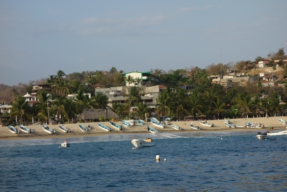
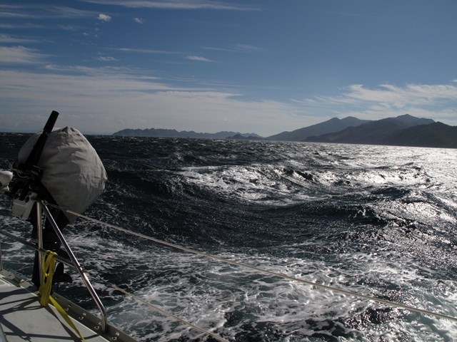
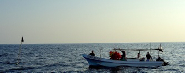
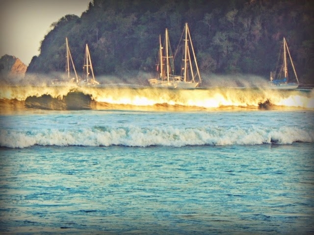
Every so often there’s an adrenaline-rush day for the small craft operators in Bahia Tenacatita, as illustrated in this photo taken by Aimee aboard sv Terrapin. Is the “Featured Image” missing above? Visit this post on GalivantsTravels.com.

West Coast accessories?

The first time we saw a dinghy with wheels, on a shiny new boat from California, we thought it was another example of what some of us from the little states in the eastern US think of as West Coast, over-the top, accessorizing.
Hauling the boat up the beach is easy with drop-down wheels bolted to the transom and the horsepower of the bocce players.
Hauling the boat up the beach is easy when the wheels  bolted to the transom are flipped down. Horsepower from the bocce players is useful too.
However we’re finding that a lot of the anchorages in the Pacific are open to the swell of half the Pacific ocean, and have marginal headlands to hide behind, or bays to enclose us. Our present dinghy is a ten-foot AB Alumina inflatable, more like an SUV than a kayak, as is appropriate for its duties as our one and only ‘do anything everywhere’ transportation interface. Doug has always wanted a strong dinghy,  but it also has its disadvantages.
At nearly 200 pounds when loaded with a 15 hp outboard and a full tank, it’s not easy to drag up the beach. Being inflatable, it’s not a good rowing boat. Despite its aluminum floor, we wouldn’t want to drag it over rocks, or even sand. And on some beaches you have to pull the boat up pronto, before the next wave, and pull it a long way. Once we understood what the wheels were for, we wanted some.
One basic theory is to put down your wheels and wait just beyond the line where the waves reveal themselves. When you see a potential big one, rev up and try to stay just on its back side. That way you get carried as far in as possible up. Then, hop out of the boat (you’re dressed for wetting, I hope) and haul it up before the next wave breaks. The steeper the beach, the more important this becomes. In some places, with careful timing, and a lot of luck, one might feasibly hop out in dry pants, maybe even dry shoes!
A second theory, which works pretty well on the flat beach of Tenacatita, is to not deploy the wheels. Sometimes the wheels hitting the ground can brake you before you’re clear of the surf break. But then you have the full weight of the dinghy to deal with; the trouble is getting it far enough up the beach to avoid it washing away on the incoming tide on a long day away.
 The local pangueros are expert at landing on the beach – that’s what their boats are designed for.  But they have 20′ high-bowed boats*,  bigger engines, and a transom deeper in the water, so the prop keeps a better bite. They often back in, with the propellor a bit lifted and the bow lifting nicely to the breakers. Sometimes someone (the junior crew member!) jumps in the water to keep everything lined up. Usually when a panga delivers you to a beach, you can step right off onto sand.
The panga is designed to be operated from a beach.

 Most important lesson so far

Don’t get in front of the breaking wave if at all possible, and especially, don’t get sideways to it. Also, the kill switch, which turns the engine off when the clip is pulled: you want its lanyard on your wrist and the switch in good working order. You could dump the dinghy, douse your outboard in salt water, lose whatever you were carrying, etc. Better not to chop up the remains while you’re at it. Who needs that kind of excitement?

This is the surf landing we're practicing up for.
This is the surf landing we’re practicing up for. This photo was borrowed from the blog svyolo.com, in a post called Pitchpoled in Tenacatita.

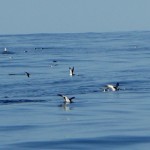
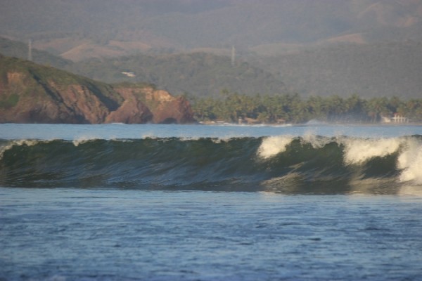
Two families with four young children between them, headed ashore in kayaks last year, and got in too far to turn back. They got dumped on the way in, and as conditions worsened with the tide, they decided to stay at the hotel down at the end of the beach, rather than take on the waves they photographed above.

It’s an interesting story, since the hotel isn’t set up for that kind of guest, and they weren’t set up to be there. But it reinforces one of our rules, which is: when you go ashore, no matter where you think you are going, always take shoes and always take money.
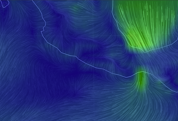
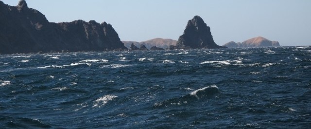
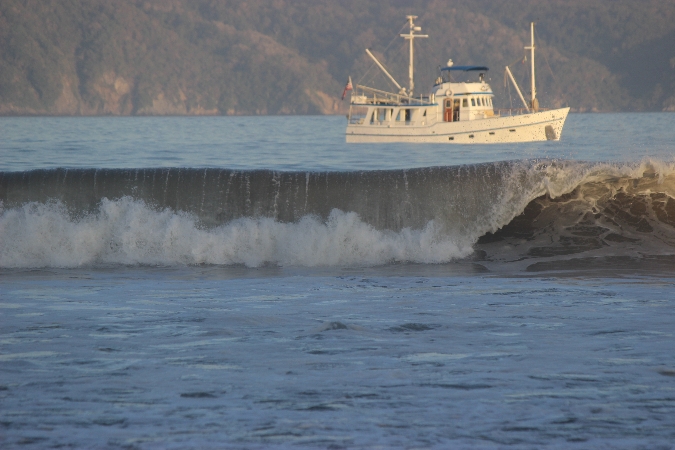
Feel the surge!

The other day we had some surge-y conditions, and I don’t think anyone went ashore. According to  surf sites like magicseaweed.com, there was a 2.3 meter swell train from the northwest, trending down some violent-looking weather systems battering northern California. And there was a 1.4 meter southwesterly swell, can’t say what is generating that without looking south of the equator. These were long period swells, up and down every 15 or 20 seconds. Listening, particularly in the wee hours, you can hear the boom of surf on the other side of the bay.

The swell, often 20 feet tall every 20 seconds, is getting them cranked in Hawail, but it, or similar swells, can affect coasts thousands of miles away.
This swell, often 20 feet tall every 20 seconds, is getting them cranked in Hawail. This, or similar swells, can affect coasts thousands of miles away. magic seaweed.com

We are well-anchored, but it is disconcerting to watch our neighbors zooming forward, as if they’re getting underway, and to know that we’re doing the same ourselves. We just can’t  feel the conveyor belt we’re riding.

Feel the Roll too

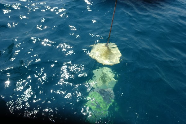
But we can certainly feel the side-to-side rolling that comes when the swell and the wind are perpendicular. There’s an accessory for that too. The flopper-stopper is rigged to hang from a pole stuck out the side of the boat. In the water is something that resists being lifted, but sinks readily, like a weighted platform, bucket, basket/check valve, or a big flat hinge. Even if it doesn’t stop the roll completely, it breaks the harmonic cycle.  That’s one accessory we haven’t yet acquired.

The 'traffic cone' flopper stopper slows down the boat's roll.
The ‘traffic cone’ flopper stopper slows down the boat’s roll.

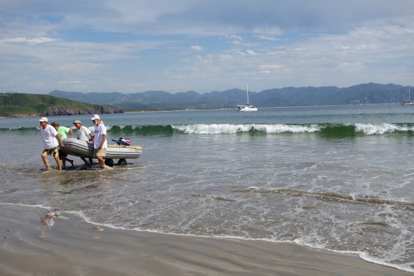
And no one is going ashore today, at least not in their dinghies. Surfing in would be one problem, getting back out would be another kind, and maybe more difficult.

Landing on the beach lessons cancelled today.
Landing on the beach lessons cancelled today. Photo courtesy of sf-terrapin.com

Launch techniques

We’re learning that the wheels aren’t always the answer to getting out either. The problem is that they leave the bow of the dinghy down, easy for the waves to break into while you’re trying to get into the dinghy, get the engine started, get the passenger aboard, stay steered straight out, etc.

They're just about to make their move, and did a great job of it, for an appreciative audience.
They’re just about to make their move, and did a great job of it, for an appreciative audience.

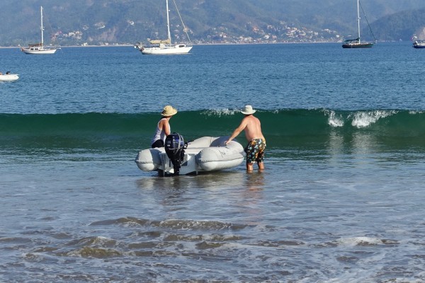
As for ourselves, well, we sometimes come home wet, and glad of a dry bag for storing things. It does help to decide early who is calling the shots, or you’ll both get doused in the space between go, go, go and wait, wait, wait!

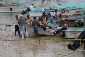
Footnote about the panga

*from Wikipedia, I learned this about the ubiquitous panga.

  • The original panga design was developed by Yamaha as part of a World Bank project circa 1970.
  • Key features of the panga design are a high bow, narrow waterline beam, and a flotation bulge along the gunwale, or top edge of the hull. The high bow provides buoyancy for retrieving heavy nets, and minimizes spray coming over the bow. The narrow beam allows the hull to be propelled by a modest-sized outboard motor. The flotation bulge along the gunwale provides increased stability at high angles of roll.
  • The original Yamaha panga design had a length of 22 feet (6.7 m), and a waterline beam of approximately 5 feet 6 inches (1.7 m).
  • Pangas are usually between 19 and 28 feet (5.8 and 8.5 m) in length, with capacities ranging from 1 to 5 short tons (0.89 to 4.46 long tons; 0.91 to 4.54 t) and powered by outboard motors of between 45 and 200 hp (34 and 149 kW). Their planing hulls are capable of speeds in excess of 35 knots (40 mph; 65 km/h)

Out of Guaymas, Out of the Sea of Cortez

In the spring, we left Galivant propped on stands, out of the water, in Guaymas for the summer, as we had done the year before. We drove back across the country to Maryland, smelling some roses on the way, to finish some house projects. And then in October we drove back in a minivan loaded with boat bits, arriving again in Guaymas at the end of the month, about when the Sonoran summer weather began to cool down to the 70s and 80s.

Flooding in Guaymas

We had seen photos of flooding in Guaymas, the result of over a meter of rain in just a couple hours on October 2, which left thousands at least temporarily homeless and roads washed out, according to thenews.mx. So we weren’t sure what we’d find.

There was a whole lot of rain in a brief period and this was the result, but it only lasted a couple hours, I was told.
There was a meter of rain in just a few hours, overwhelming the roads and sewers.
In the far far background a mile or two away is the dry-storage yard where Galivant was hauled out. We got excited when we saw this picture, but there apparently were no similar consequences.
The malecon flooded too. In the far far background on the other side of the bay is the dry-storage boatyard where Galivant was hauled out. We got excited when we saw this picture, but there apparently the boatyard stayed high and well-drained. Photos from thenews.mx.

Everyone we asked in the downtown area pictured above just shrugged.  In short, downtown was dried out and back in business with no problems readily discernible to the outsider.

Roadwork too

But there is a lot of new, and necessary, road work going on. There is major work on the road to the boatyard, involving an extensive excavation one foot over and three feet down from every passing tire. New water pipe awaits installation nearby. There were numerous shifting detours through pot-holed and puddled neighborhoods. Washed-out dirt-rock side roads are gradually being graded, even paved. Poles, piles of rocks, and other eclectic markers keep the alert day-time driver clear of missing manhole covers. Driving in town was quite the adventure this year.

The new gobernadora* may be the one responsible, or maybe it’s been in the mill for years, brought forward by the big rain. Certainly,  everyone, –drivers and water users, roadside business owners, bus passengers and cyclists– anyone who uses the roads or depends upon those who do  — will breathe a huge sigh of relief when the holes, ruts, potholes, and ditches are finally filled in and evenly paved.

A public banner showing a couple happy and relieved at the state of the new road behind them. This is a bad picture, and from the state of Nayarit not Sonora besides, but the sentiments are surely the same. The companion poster shows workers putting bright yellow paint on a speed bump, which would also be cause for rejoicing were it the new standard.
A public banner showing a couple delighted at the state of the new road behind them. This is a badly exposed picture, and from the state of Nayarit (looks like the Punta de Mita road) not Sonora besides. But the sentiments are surely the same. The companion banner showed workers applying bright yellow paint to a speed bump (tope), which would also be cause for rejoicing were it the new standard.

 We spent a long month out of the water at Gabriel’s Marina Guaymas working on things. We still like it there, finding it a friendly and straightforward do-it-yourself yard. What’s to Like about living in the shipyard tells you more about that! Nonetheless, we’re not motivated to linger longer than necessary when there’s so much to see and do over the horizon.

Finally free to move, we faced a decision: should we head back to familiar places on the Baja side of the Sea of Cortez?

Last winter we stayed in the Sea of Cortez, and we enjoyed it thoroughly. We found the rugged Baja scenery striking, and liked the exotic emptiness of the landscape. I read as much as I could about the area (a lot about geology), and would like look around some more.

It was nice, but it was also  – well, cold would be an exaggeration, perhaps an offense to those under the chilly mantle of actual winter. In fact, despite the occasional dips of overnight temperatures into the low fifties, the days were usually sunny and seventy plus – pretty pleasant in my book. But I do like to don my snorkel and mask, but not my wetsuit, and swim along the shoreline looking at whatever there is to see. And the water temperature never got above the mid-sixties, which is – cold!  Too cold for a whiney woman in a lycra suit, anyhow.

So this year, lured by daily morning radio reports from other boats of balmy temperatures (“water in the pool 83 degrees”), we turned south from Guaymas.

Heading South

The trip out of the Sea of Cortez can be broken into comfortable legs with stops along the Baja peninsula, but we took the straight-down-the-middle approach, which made for a roughly 600-mile trip to Punta de Mita at the mouth of Banderas Bay. It took us five days.

Satellite image of mexico track labeled copy
This is not our actual track, which was more of a downwind zig-zag. Map courtesy of geology.com, I think.

The winds at this time of year are almost always northwest or some variant thereof, which, since we were going southeast, might be considered a fair breeze. Driven by systems ‘across the fence’ (that’s how Geary the weather guy refers to the US and Canada), the northerlies can be strong and persistent. Those steady 20+-knot winds that send us south (and keep us there!) also chunk the seas up into short square blocks. “Seas five to eight feet at five seconds” is not an uncommon weather report, and one that makes for uncomfortable sailing conditions.

So when you wish your friends “fair winds”, make sure to add on “smooth seas” too. Also, by the time we got moving, the moon was in its last quarter, rising after 2 am and dimly, when not clouded over entirely. I seem to have spent a lot of time in my life waiting for a moon to rise, then being surprised by it when it does!

The trip south was a mix of screaming along downwind at the northern end and drifting along in not-enough wind at the southern end. We’re a little cautious (or is that lazy?) about sailing efficiently in the dark of night. It’s a complicated rig of hardware, poles and guys, that keeps the sails from crumpling as we roll off the waves. We mainly don’t want to have to spend much time on a rollicking foredeck when we can’t really see all that’s happening. So we tend to reef early and accept compromises to speed in the name of comfort.

Afloat in the universe

The occasional freighter bound for Guaymas or Topolabampo passed at a distance but otherwise, it was just us and our modest red, green and grey navigation and instrument lights. While one of us sleeps, the other sits alone in the dark in the middle of the sea contemplating the universe. I suspect there is sometimes napping as well.

Anyhow, there’s plenty to think about. The firmament, for one, beneath whose dome only we two know that we are here, a minuscule moving mote. I think about the generations long gone who studied and named the night sky, and of the eons beyond counting that the stars have endured, and will endure, beyond whatever we can do to our planet. So, alone, even melancholy, and yet exhilarated too, by the luxury of real darkness in this age of artificial light.

The heavens may be “empty” and silent, but the nearer world of water, ceaselessly sloshing inches away, is anything but quiet or still. The waves do the same thing over and over, only differently each time. It’s mesmerizing. The laws of physics seem quite reliable, gravity in particular.

Breathing metaphors come to mind, heaves and pants, hisses and sighs. It does seem wrong to associate the ocean with breath, because of course it’s the last thing you can do in it. So stay on the boat, keep the water out and maintain buoyancy throughout at all costs!

We always think these shortish coastal passages are harder on the crew than ocean passages lasting weeks. On the short haul, it’s harder to find the rhythm of sleep and watch-keeping, and closer to land, there are more ways to get into trouble. But short trips end soon enough, and then you’ll wake up to find someplace new and different.

sunrise, calm seas, toenail and cleat
Out the galley window as we arrive in La Cruz de Huancaxtel, Banderas Bay. I wonder what’s in there?
Footnote:

*There was a nationwide election in Mexico in June 2015, and the winner for governor in the state of Sonora was the PRI candidate, Claudia Pavlovich, the blonde woman on the political posters which sprouted on roadsides throughout the spring. Although she lost Guaymas proper to the PAN, she won statewide with about 47 percent of the vote.

According to Wikipedia:

Claudia Artemiza Pavlovich Arellano (born 17 June 1969) is a Mexican politician and lawyer affiliated to the Institutional Revolutionary Party (PRI). She currently serves as Governor of Sonora, the first woman to govern the state. Her family is of Montenegrin descent. [1] Previously she served as Senator of the LXII Legislature of the Mexican Congress representing Sonora.[2]

And the PRI is the party that ruled Mexico for much of the previous century. It is also the party of the country’s current president, Enrique Peña Nieto.

Random notes on Pacific Mexico


strong winds blow across the isthmus into the Gulf of Tehuantepec

Weather is always on our minds

My new favorite weather website is this  earth.nullschool.net/#current/wind/surface/level/orthographic, a graphic representation of the actual winds being reported, available for the entire globe. In this picture of southern Mexico, the big green part is the tail end of a cold front passing through the US with a tail extending across the Caribbean. The small green is where those winds have funneled through the Chivela Pass across Mexico into the Gulf of Tehuantepec.

…especially Tehuantepeckers

The next day’s NOAA weather forecast for a 90-mile swathe of the golfo is INCLUDING GULF OF TEHUANTEPEC…N TO NE WINDS 30 TO 50 KT. SEAS 12 TO 17 FT. This kind of weather is a regular feature of the winter months. In fact, according to one of their blogs,  NOAA issues more gale and storm warnings for this area than for any other, except during hurricanes. They (the ‘fleet mind’) say small craft like us should negotiate the 240-mile crossing area around its edges, with “one foot on the beach”  or “close enough to hear the dogs bark”. But we were approaching this area at the end of its heavy season, had a four-day forecast for light winds, so we mainly motored straight across, and right into the marina in Huatulco to buy more diesel fuel.

And you can also see in the null school.net image, there’s not much wind elsewhere. That’s been the situation for most of our trip towards the Sea of Cortez and Baja California from Panama throughout the early spring of the year. (But not all of it: Too much wind, or not enough). Sometimes there’s an onshore breeze in the afternoon and offshore at night, but lots of lulls and opportunities to motor, against the current too.  Here is a picture of ocean currents, also from nullschool. I could watch  for hours; better than TV!
ocean currents off Mexico nullschool
We’ve had our new engine for four years now but we have put at least thirty percent of its hours on in the last six months. And we’re darned grateful to be able to motor, considering the alternatives.

Ship Traffic

When we’re underway we always have our VHF radio tuned to Channel 16. I heard a ship, the container-carrying Maersk Wolfsburg, call another ship on to ask what conditions he had seen in the Gulf of Tehuantepec. “Force 4, in advance of a much bigger blow being forecast” was the answer.  It’s the first time I’ve heard big ships talking with each other to exchange information not directly about course changes. I figured they just steamed through all weather no matter what.

Our computer keeps track of each ship it has seen, and doesn't delete them when they are no longer 'targets'.

OpenCPN, our computer’s navigation program,  keeps track of each AIS ship it has seen, and doesn’t delete them when they are no longer ‘targets’, leaving the screen cluttered with ‘ghosts’. There’s more traffic than we would have known, but we never see more than one or two, if that, at a time.

Then a couple nights later, I heard my first Mayday. It was another container ship, reporting a man overboard, and giving the position. We were about 150 miles north and not in a position to do anything. Then it transpired that the MOB position was estimated, since the person had been missing for two hours. And then the Mexican Navy broke in and there were no further transmissions. Google tells me nothing more. For me it was a somber watch, dark and moonless,  on the edge of windy and rough for us in a 40-foot boat,  and for a man in his skin, well…..

What else could go wrong?

running man sign
Not the official warning sign, but the message is the same.


We were in a small bay outside Huatulco when we heard of the tsunami alert following the earthquake in Chile April 1. Thankfully, nothing materialized here, but we did get to think of what might happen and what we could do, not that we have any real answers to either question. Except, move to higher ground probably won’t be an option.

We also heard a report from a sailboat at anchor in Acapulco during one of  two recent  big earthquakes there, one a 7+. Anchor chain rattling and grumbling, palm trees swaying, a small rockslide or two is what you first notice, they say. That boat (sorry, I didn’t get the name) up-anchored and left immediately, fearing tsunamis. Probably I’d still be scratching my head!

But I did read a bit more about the earthquake warning system in place for Mexico City, which is situated on jelly-like landfill and has suffered greatly from past terremotos. http://www.economist.com/blogs/economist-explains/2014/04/economist-explains-14

Many of the earthquakes take place inland in Oaxaca along the intersection of the North American plate and the Cocos plate. Seismic waves move 7000 miles an hour, but the alarms are almost instantaneous, giving the folks in Mexico City at least a chance to get out of buildings.

 Not all anchorages are good anchorages

In fact, there aren’t that many all-round good anchorages on this coast. The surf/swell/surge from all that open ocean to the southwest is a constant feature. You know it’s not going to be great when the most prominent comment is about the surf spots nearby. We like to be enclosed and protected, but we’re getting used to the open-ness and the rocks, sort of.

One night we shoe-horned ourselves into an anchorage in Puerto Angel, something we won’t be doing again unless the harbor is somehow enlarged or emptied. All night long we moved between the rocks on one side and the rocks on the other side, but managing to stay clear of the moored boat 20 feet away. There was a big surge  in the harbor, and a very steep beach, so as I peeped out the porthole I had the distinct feeling that I was already halfway down inside a vortex, ‘down the gurgler’ as the Kiwis say, and I didn’t like that!

The beach is very steep and the local boats motored and surfed their way up it.

The local boats without  moorings just surfed a wave with their outboards full on until they hit the beach and, they hoped, kept going up.

And not all charts are good charts, except the iPad’s charts

We do carry some paper charts, although of course the electronic ones are a bit more convenient. Coastal charts like the one above with the AIS ghosts are off by a mile or more. By their offsets, we’re usually on the beach when anchored. I would have gagged on the words not too long ago, but I have to admit that our best charts and our most used close-to-shore navigation interface come from the iPad. The iNavX’s Navionics-based charts seem mainly accurate, and the charts from the top-notch Mexican cruising guides Pacific Mexico and Sea of Cortez (by Shawn Breeding and Heather Bansmer) can’t be beat.  These harbor charts can be downloaded thru the iNavX app (Blue Latitude Press), and the waypoints are also available as a separate download.

Dolphin Feeding Frenzy

Saving the best for last:  one day we saw this fantastic dolphin feeding frenzy, or party, or whatever it was. There were at least five hundred (guessing!) leaping, twirling, splashing, dolphins moving back and forth on both sides of us for twenty minutes, until a message came in from somewhere else and they moved on.

dolphins leaping


We were lucky to be part of the party as we sailed silently through. And if I’m lucky one of these days, I’ll be able to upload the video too.

Too much wind, or not enough

We did a fair bit of motoring in south and central Costa Rica because there was just no wind. Then we got to the north end of the country where, at this time of the year, they often have too much wind. The Papagayos, as they’re called, arrive from the northeast thru gaps in the mountains of the isthmus downstream from the western Caribbean, which gets them from the frontal systems that bring eastern North America their winter storms. See, it really is all connected!

paorama Bahia Santa ElenaSo there we were in the snug shelter of Bahia Santa Elena, a national park, all checked out of Costa Rica and on our way to Nicaragua when the proverbial weather window opened. But wait, a hike to a waterfall with some new friends? The answer is always yes. In this case, the land looks pretty dry and it was puzzling that there could even be enough water for a bathtub in the dry stream bed that is the start of the path to the waterfall.

dry stream bed Santa Elena

But the water gradually filled in, and at the end, eureka, a modest water feature in a refreshing little pool.

Santa Elena waterfall

Our friends were going south, we were going north, and the Papagayos were supposed to start building the next day, but when? One of us was going to have a nice day.

southbound in the Papagayos This photo, courtesy of Pat on Always and Forever, is what our friends got; they ended up blowing downwind in 30-plus knots with no sails up at all. Our end of the stick was a little messier, because we were going where the wind and seas were coming from. Doug steered up into every lull, but it soon became apparent that we would be unable to lay Bahia San Juan del Sur, Nicaragua, our intended destination. Luckily, 7 or 8 miles further on, there was another bay, Pie de Gigante (Foot of the Giant), which we did manage to get close enough to to enter, and with a gigantic sigh of relief we stayed put until conditions moderated a day and a half later.

That gave us time to investigate  small losses in the engine’s fresh water cooling system. Eventually, rather than take the chance of doing damage, we decided to head straight for Mexico without dawdling in Nicaragua, El Salvador or Guatemala, and without using the motor. Thus began a trip that could theoretically be done by us on four good days, but took us more than twice that time, especially after we left the Papagayo wind zone.

It is easy to think of hours spent becalmed, rendered motionless by lack of wind, as hours wasted. In my opinion, the hours I wasted were the ones trying to make the boat move on zephyrs. You get to think a lot about the mariners of yore trying to make their way through these waters in heavier and more awkward vessels, without a stack of books to read. Too hot to cook, and we’re at the bottom of the propane tank anyhow. The fridge is turned off, and reveals itself to be the consumer of two-thirds of the power we use each day. Ships pass by on their way to Puerto Quetzal, or Acajutla or Corinto; the AIS tells us even when they’re too far off to see. Tick, tick, tick.

sailed route along Central American Pacific coast
In our 8-plus day, 440 mile trip, we had a day’s run of 28 miles, another of 40, and lots of tacking. Don’t worry about the Man Overboard icon though. That was a slip of the finger not a slip of the foot.

The glassy seas reveal more turtles than I’ve ever seen in a patch of ocean. Some of them had sea birds sitting on their backs. There was a wealth of dolphins, and, always at a distance, leaping dorados. No trash on this stretch of sea, thank goodness. Seabirds look us over, and some start to land and settle in.

Doug poked him with the boat hook and chucked buckets of water at him, but the booby wanted to stay, and did.


Maybe these are pink-footed shearwaters. They made about fifty passes before their successful landing on deck. But when one left, they all left, except the one who had wandered off under the dinghy, found the open hatch, and went down into the cabin. It sat calmly on the companionway steps, until I finally covered it with a towel and delivered it back to the open skies.
Maybe these are pink-footed shearwaters. They made about fifty passes before their successful landing on deck. But when one left, they all left, except the one who had wandered off under the dinghy. That bird found the open hatch, and went down into the cabin. It sat calmly on the companionway steps, until I finally covered it with a towel and delivered it back to the open skies.

Just so you don’t visualize all torpor and sloth, there were several adrenalin-filled spells as well. The most prosaic was the squall,  at 4am, under a dark cloud that first paralyzed us by stealing our wind, and then, like a spider waiting for the poison to take effect, pounced to shake us up. With heat lightning bright enough to read by in the clouds, but enough forks coming straight down to keep us sitting bolt upright below, not touching anything metal, it was a long half hour. Good thing we had plenty of sea room, being 40 miles offshore.

At least we thought we were alone. But the next night there was a little twinkle of light on the horizon, and then a minute later another, maybe not so imaginary after all, and maybe not so far away either. Peering into the dim as we ghosted along, we decided that the tiny flickers marked fishermen sound asleep or, more likely, their apparatus. It was nerve-wracking trying to steer around something we could only see once a minute, and a great relief at daybreak to not see anything at all.

Then, up from nowhere zoomed a lancha, come to inform us of their floating polypropylene line (holding up a sample!) in the water in front of us, and to show us which way we could go to get around it. In the next couple miles, 44 miles from shore, there were three more ‘fields’ of isolated floats and poles, not one with a light, and that’s the last we saw of fishing, that we knew of.

40 miles offshore, these fishermen came to steer us around their long lines.

The third excitement was the visit from the whale.  It’s a real thrill to see something so big and ‘charismatic’, to see the blow and watch the power of its movement. But, it’s close to frightening when all of that is nearly as big as we are, and a mere sixty feet away. I felt like this was a young and curious whale. I say young because its skin was clean and dark, not like the barnacled ones I’ve seen in photos, and curious because it circled us a couple times at close range and dove under the bow like a dolphin, before it lost interest and  vanished. I  tried to take a video, but this was not the time for learning how. Better to sit and absorb the ‘whale-ness’ of the moment, then to breathe a sigh, regret mixed with relief , when it was over.

And another sigh of relief as we ‘becalmed’ ourselves to a marina dock in Puerto Chiapas, Mexico. Our cooling problem was not a blown head gasket, or anything drastic, just a leaking o-ring and a loose fitting. And of course, we’re both better people for facing the wind, both kinds, unmediated by the convenience of ‘el motor’.