Bocas del Toro, Panama

If, like me, you didn’t quite know where Bocas del Toro was, you’d soon find out.  According to  the SSB radio realm of the Southwest Caribbean Net,  Bocas is the West pole  of the universe, Cartagena being the East, and the San Blas starring as the Shangri La of the tropics.  Where is Bocas and why are so many people going there?

Eyes top left!

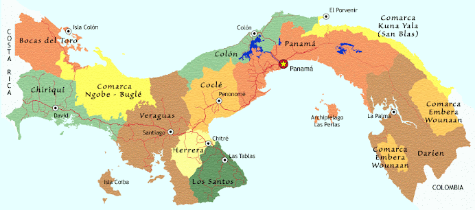
Map copied from the blog   peaceinpanama.blogspot.com, by a Peace Corps volunteer in the Bocas area, nice-sounding woman, as I find generally of Peace Corps workers, and worth a look.


image

this map courtesy of escapethatcube.com. If this were a chart, you would see that the water depths are surprisingly inconsistent; the water is often clear, but the bottom holds many surprising contours.

Bocas del Toro is the indented bay and its half-dozen neighboring big islands at the far western end of Caribbean Panama, abutting the border to Costa Rica. The Bocas del Toro province itself extends halfway to the Pacific; the mountainous interior is populated, if at all,  largely by Ngobe Indians in an often subsistence condition. Bananas are the primary export of the coastal mainland part of the province. Once they were the economic mainstay of the islands too, but diseases crashed the crop years ago and nowadays the economy is mainly tourist-based.  C. Columbus was here on his fourth and final trip and named a few more things. Bocas del Toro lies 130 miles mas o minus, from the Rio Chagres, basically due west.

Bocas the Town is on Isla Colon. The mainland hub, such as it is, of these islands, is Almirante, a twenty-minute lancha ride away. A car ferry like you’d see in the Outer Banks of North Carolina also arrives every morning laden with delivery trucks which do their business then depart every afternoon.

P1080905

There’s another  town, Chiriqui Grande, in the next bay south, and you could also arrive in Almirante by bus from the Costa Rica border at Changuinola. Otherwise, there are a few planes from Panama City which land at the Bocas airport, just  a short stroll from the waterfront. The other islands are accessible only by water taxi, lancha or private boat. P1080894


So, what’s this place all about? To me it looks like Bocas del Toro is Shorthand for: don’t worry about hurricanes, or, really, any weather beyond rain. Be a gringo in the bosom of your tribe.  Eat in restaurants! Drink wine and eat fresh vegetables every day! Wash your clothes in automatic washing machines! Ride a bicycle if you’d care to! Test your powers against the persistence of mildew and no-see-ums. Plug into  shore power if that’s your wish. Get on an airplane connecting to anywhere! Watch the rest of the careworn world from a respectable distance.

PHOTO HARBOR VIEW OF COASTAL MOUNTAINS

Bocas morning water front

Many of the turistas are backpackers, big hairy guys and tiny little girls  both laboring under the same-sized packs.

Surfers come here – not too many in this  rainy season (US summer but the Panamanians call it invierno winter) when the trade-wind generated waves don’t pile up on the reefs and beaches so  much.  But it’s fun to read the surfer descriptions of the area. Apparently you need to be ‘confident’ because a couple of the best breaks end on top of a reef which I’m sure could scrape you up pretty badly.Bocas Del Toro Surfing – Isla Colon – BLuff and Paunch

surfboard bike pedestrians Bocas town

Bocas is the kind of town where the main street contains more pedestrians and cyclists than cars and you can easily stroll the six or seven blocks of its length down either lane of the street, without dodging anything but a backpacker,  bicycle or chat group. The bikes are generally fat-tired ‘beach’ bikes – we always think of them as luxury rides compared to our little boat bikes.

But we did get those out for a few rambles, including one up and down and up and down across the middle of Isla Colon. There it’s sometimes lush and untouched, and in other places cleared for cattle, pretty in a rolling Pennsylvania Dutch kind of way, minus the barns. Signage indicates something in the law permitting ‘reforestation projects’, one of which might be the increasingly-popular teak tree plantation we saw.http://www.panama-guide.com/article.php/20041121094452818


PHOTO BIG TREE HANGING VINES

20110713Bocas del Drago-007-32

Yachts have been coming here in ever -increasing numbers – but as we’ve found in the Rio Dulce, Guatemala and other places, often the boats are parked and empty while the owners have flown back to Europe or the US for a few months. There are three marinas in the Bocas area, and rumors are flying about a soon-to-be-contructed haulout facility in Almirante. This, if true, would really change the cruising equation; the nearest haulout otherwise is back in Colon at Shelter Bay, with a reputation of being pricey and prickly in some of its policies. The other alternative, Cartagena, is hundreds of up-wind miles away.

Bocas has a number of old houses converted to hostels, and a handful of modern ones too, lots of bars and restaurants, a surprising number of Chinese-owned grocery stores.  You can buy computer parts at the pharmacy, and motor oil at almost any grocery.You can get  a massage, a tattoo and who knows what else where else. To my mind, if the cornucopia that is Chow Kai Ferreteria doesn’t have it, I don’t need it!


20110630Bastiamento hike-006-8

PHOTO WATER TAXIS

P1060630

Being a tourist town, and a group of islands, prices are a little higher than other places in Panama. The locals who profit from the present invasion are probably pleased by increasing ‘gentrification’ but in the background, or sometimes right next door,  is  a basically rural, undereducated, poor indigenous population who might not do so well.

P1080830

PHOTO

The slow global economy may be delaying development just now but in the meantime the Panamanian government is actively encouraging US and European investors  to settle in Panama if they have a certain monthly income or other resources. I’ve been told it is an effort to replace some of the ‘economic stimulus’ that disappeared when the US population of the Canal Zone left twenty years ago. And the newcomers are not all old people either – we’ve met a few young couples living in Bocas and Boquete (inland, another post)who work via the Internet, or start restaurants and other small businesses.

One hotel displays photos from over a century ago, when the Bocas area was prime banana growing territory.  Every time I see old photos like this, I wonder where the trees are.

PHOTO OLD BOCAS FRUIT CO HQ

P1080911

The bulk of banana plantation activity has moved to the mainland, but Bocas town still has a few of the older buildings, despite fire, storm, earthquake and development, including some charming raised up wooden cottages with porches and gingerbread, now often serving as backpacker hostels.

PHOTO OLD WOODEN HOUSE

Bocas houseo

The surrounding islands have varied personalities. Solarte seems to attract the jungle-loving new arrivals.  Bastiamento, has a small town, Old Bank, the newest marina, Red Frog, a good surfing beach, and a national park. We had a great hike out there one day (another post). Others have jungle,  some specialized production, like gourmet chocolate (I’m practically addicted to one of the locally manufactured brands), or have been substantially cleared for low level cattle  production.

P1080907

All in all, until the great tourist boom comes, it’s active but not frantic around here, at least not in the rainy season.

If you’re reading between the lines, you might discern that I sort of like it, and I sort of don’t. We look at the  number of gringos in their new ‘tropical estates’ with a mix of emotions. How can they commit to this? The bottom line, for those we’ve been able to ask, is that their money goes farther here, they think. But I keep wondering: How can they build a wooden house on a low-lying island, often cheek by jowl with some other self-important ex-pat, or next to a poor native village,  in a country where they don’t speak the language and don’t understand the work ethic, where they often don’t have much nice to say about the people, even if the hurricanes don’t come here and the internet service can be good?

Of course, there is way more to Bocas del Toro than the little I’ve stumbled through here. We, as usual, have more questions than answers out here in our floating palace.

Clearly, there are advantages to Panama, particularly for the investor (tax concessions and relatively low, although rising, prices),and the retiree: ( ‘third age’ discounts, less expensive decent-quality medical care). A stable government and a semi-Westernized culture familiar with US methods and products from generations of American presence in the Canal Zone works for everyone. There’s a lot to like,  but is it all that nice? It would be easy to get stuck here, on a lee shore, at the far downwind end of the Caribbean.

Technorati Tags:

Rio Chagres

When Doug and  I wanted a place to hang out in peace and quiet for a little while after the bustle of Colon, we thought –let’s try the Chagres! It’s a river (fresh water!) running through a jungle, with not too difficult an entry in the right conditions, just around the corner from Colon and all its associated activity, Panama Canal, and otherwise. As usual, I liked it hugely. I’d still be there if Doug hadn’t insisted on leaving, and everything we own would be fresh-water clean.

This Google Earth image is pretty choppy, but you can see the Rio Chagres outlined  in blue and running diagonally across the page.  Maybe it looks better on a decent-sized monitor? The mouth of the river and  Fort San Lorenzo are top left, the dam and spillway  and lake at bottom right, near the set of three locks.  Just off the top center of the image is Shelter Bay Marina and off top right, the main breakwater for the canal anchorage. From the old map (courtesy of inadiscover.com)  you can see what they had to work with in the beginning. Reminds me a little of some of our charts, especially the typeface.


 Chagres GE croppedBayofPanama-map historic

gGOOGLE EARTH, HISTORIC MAP

When the Panama Canal was built, it was this river that was dammed to enlarge Gatun Lake and ease the transition up ?85 feet? from the Caribbean side. In fact, I’ve read that Chagres is the only river with outlets on both oceans, although I think that’s counting using the other set of locks as egress. It was  the major highway for the Spanish conquistadors moving their treasure from the Pacific side to the Atlantic.  When Henry Morgan the pirate went to Panama City to raid Spanish coffers, it was the Rio Chagres that he used as a highway.  Later on it was something of a short-cut for those seeking, and returning from, the California Gold Rush. I imagine there was a good deal of rowing involved.

Now that we’re here, however, things have calmed down considerably.  We entered at Fort Lorenzo and eventually motored all the way up the more=or-less consistent-width channel to almost within sight of the Gatun Lake spillway, about six miles away, 30 or 40 feet deep all the way. During our entire stay we saw one handful of local fishing boats and pangas, two yachts up at the end, a fast-flying flotilla of military persons, 2 men on a trail, and that was it – way more monkeys than people inhabit the river I saw. It’s all protected park land; if you can believe what you read online it is protected because they need to conserve as much as possible of the 200+ inches of annual rainfall for lock operation. They’ve learned that water just runs off from the developed land. The new canal, by the way, is being cleverly engineered to conserve its water; a good thing, because every locking of the present canal uses 52 million gallons. Or something like that!

Here’s how the Rio Chagres looks from the fort,  San Lorenzo,  which the Spanish last re-built around 1750, to protect  the treasures it was attempting to remove from the continent. The US fortified it during World War II to protect the Canal. These days it’s just the usual semi-inscrutable collection of cannons and ruins, weed-whacked to blankness. We pedalled up here from Shelter Bay Marina on our bicycles one  morning and later had a joyride downhill toward home, plus howler monkeys, frogs spawning in puddles, free ice-cold water from a cruise-ship tour bus, and a little overheard rifle-range practice. This land was once, (?from the 1950s?)in the US era,  and apparently still is, used for jungle combat training.

rio chagres from fort san lorenzo

PHOTO LOOKING UPRIVER FROM THE FORT

To the left, there’s a  dock with road access, popular with fishers. Partway upstream,  and well inland, you can (with super zoom, maybe) see the top ‘bar’ of a big crane, which is said to be part of the Smithsonian’s jungle canopy research project. Too bad we couldn’t figure out how to get there by foot. From the river the  bushwhacking required looked very intense, even if you could keep track of where you were and were going. (no GPS satellites pierce the vegetation)

Although, I gather that once you find the rainforest proper, the understory  is actually clear, even airy, with the bulk of the activity in the canopy. This from a book I’m reading and enjoying, Tropical Nature by Adrian Forsythe, available in Kindle format, and recommended for anyone near Central American tropical forests.

We anchored near the fishing dock for a few hours. Doug wanted to check out the wreck on the beach just outside the river mouth.image

PHOTO REMAINS OF CIELO ON BEACH

This wreck dates from December 2010. There was so much rain here at the end of the rainy season that the Panama Canal was actually closed to traffic for a day or so, for the first time ever, I gather because of the amount of vegetation in the water. (By comparison, this pleasant little rain shower wasn’t even a drop in the bucket, but the monkeys always howl when they start to get wet.)

chagres raining

RIO CHAGRES RAIN FOREST IN RAIN

The Canal Authority sometimes lets excess water out the spillway, first sounding a siren to warn the fishermen who congregate on the rocks and shoals immediately downstream. This wrecked boat wasn’t flushed all the way downstream by spillway water, but I gather he was either anchored or trying to anchor at the mouth and just couldn’t withstand the forces against him. Doug took a few tools just in case, but the boat has been neatly but very thoroughly stripped.

We spent a couple very pleasant days where the river makes a ninety-degree turn and we could have views in both directions.

chagres view downstream 

RIO CHAGRES DOWNSTREAM VIEW

By dinghy we explored several little streams that meandered in from somewhere, looking for the one with the waterfall, but the pleasure of that was in the search, not in the realization.

chagres buttress roots 2

CREEK BUTTRESS ROOTS

This corner was popular with cicadas and/or frogs (hard to know what we were listening too, but it lasted all day!), howler monkeys and shrieking lorikeets; very occasionally we could hear a discordant ship’s horn from the lock or lake a couple miles off.

chagres howler 'family' 

HOWLER MONKEYS IN BREADFRUIT TREE

Needing to make a parts order we eventually went up to the end of the river ourselves, where there were two other yachts in residence. Having heard of theft issues at the little public landing, we rowed the inflatable there, and we did notice that no one left motors on their boats, and that the boats themselves were heavily chained and locked. So the dangers of the rainforest seem primarily human. Also, from the end of the river the soundscape was a little less ‘jungly’ and more along the lines of very occasional dumptruck tailgates bouncing and buses without mufflers, plus there was the sodium vapor loom of the lights of the  Gatun lock.

chagres downstream of spillway dam container ship and repair barge

GATUN SPILLWAY DAM CONTAINER SHIP REPAIR BARGE HIGHWAY BRIDGE ROCKS

However from the dam end of the river we could have taken a bus back to Colon, only a few miles away, for supplies! And I actually did communicate with the outside world briefly:   I sat near the side of the road (actually, in the parking lot of the defunct Tarpon Restaurant – there are tarpon in this river too – we saw scales as big as my palm in some fishing places). My laptop was on my knees and the cell phone modem dangled from a branch, with the two bars of service I needed to order some boat stuff for ocean shipment from Florida to Panama City. I’m still giddy at being able to do this, but need to remember to check for ants before sitting or leaning on anything! And I apologize to anyone whose email I should have answered right then and there…it was the ants!

No swimming because of the one crocodile I saw one time, but it was BIG. When the climate got hot and breezeless, Doug poured buckets of water on himself; I have a big sponge for controlled dribble.

We went for a hike on a trail that turned out to be the remains of a railway built by the French at the end of the 1800s in their unsuccessful canal-building attempt. It was level and may have gone all the way back to the river mouth, but we didn’t go that far, thinking we’d be unlikely to notice any difference in landscape between here and there. There was plenty to gawk at already!

yellow leaf footprintchagres butterfly

My ongoing  reorganization scheme will eventually lead to some online albums, but for now, I’ve got to get caught up with places we left a month or more ago!

Where the Water Meets the Road

One of the great pleasures of Kuna Yala, these islands along the Panamanian coast otherwise known as the San Blas,  is that STUFF isn’t just pouring in, dumped out of the huge container ships constantly streaming past just over the horizon, en route to the Panama Canal. Even if, sometimes, it looks like the containers themselves are pouring in, I only saw this one.

This container on the beach, washed up not too long ago at Esnasdup  illustrates a previous point that containers really DO sometimes get away from their ships. PHOTO ESNASDUP CONTAINER . 20110327-container on Esnasdup beachP1030090

It passed over a small reef and scraped, surprisingly lightly, through the shallows before it landed here. The copper pipe and refrigeration system is gone, and so is the insulation, scraped away for access to the pipe and then removed by ‘aeolian transport’ (wind). The roof is gone too, as if by a P38 can opener, otherwise, the container would be ripe for colonization. Contents? History? Mystery!

Life is close to the bone, or rather, to the vine, to the tree, to the reef, for the resident Kuna people.  There isn’t much in the way of the manufactured goods, or the money to pay for them, here. Of the things seen in use and for sale in the tiendas, much of which is either Chinese, or sugar-based,  my question has always been “where does it come from? How does it get here?”

Well, now we know a little. Many goods  flow in in pickup trucks and jeeps to Carti on the one road that penetrates the Comarca of Kuna Yala  from Panama. On a good day, according to some campers we met on an outer island, they can get to Carti from Panama City (which is on the Pacific coast of the isthmus) in ‘just a couple hours’ on a road that is properly paved, down to the yellow line down the middle. The campers came in their own car, probably paid some “Kuna tax’ for using the landing, or the road?,  but the Kuna collectively also own a number of jeeps, which ferry goods and people from the city.

This part of the road looks good, but further along it is subject to landslides and other degradation in heavy rains. The terminus is on what used to be the runway of the Carti airport.

The airport no longer operates; the road does a better job of what the airport once did. I’ll also mention that  the dozen or so small airports that dot the coast seem to have been built by the US during WWII, part of its canal protection scheme.  Anyhow, I’m a little unclear about all the details of the road, save that it can be done.

PHOTO PICKUP TRUCK BEING UNLOADED

So we sat in the shade and watched the various loadings and unloadings taking place along the beach. Clipboard01 dock at Carti

cartu loading cycle into lanchaPHOTO MOTORCYCLE BEING LOADED

Then there were the three gringoes with the two motorcycles at the end of the dock. Since there is no road all the way through the Darien (which is keeping that last bit of rain forest safe for now), they were travelling to Patagonia via Cartagena, and to Cartagena via one of the several so-called ‘backpacker boats’.  Fritz the Cat, one of the largest and longest established members of that tribe, straps up to five bikes along the side decks for the ?five day trip, (3 meals, less than five hundred dollars, I think). Here’s how the bikes get that far.carti bike to backpacker boat


I should mention that this spot is open to the prevailing trades and that we were there during relatively settled conditions. Like the local lanchas, we anchored a bit off and waded ashore, not the most elegant way of arriving, but better than being flipped or bounced off the bottom. P1030844 fritz the cat

There’s another ‘local’ landing, this one a little way up a nearby river and down an unpaved road. Motorized ulus use this one, and here all a lady has to do to exit is step gently but firmly.

PHOTO RIVER LANDING P1030866 board your carti river excursion here

.

Laundry Day Two: the river

A couple weeks later, we had sweated,  spotted and stank (or should that be stunk?) up all our clothes, towels and sheets again. The household deities offered clouds and sometimes lightening, but no precipitation. So we decided it was time for a river trip. The pipe that supplies the town, at Nargana, at the Rio Diablo, has apparently been broken for some time, so it was easy to follow the trail of ulus full of bottles, jugs and drums into the mouth of the river, between numerous tree trunks and snags,  over the 14-18”bar, in to a pleasant lazy river full of fresh water.

So far we’ve seen mostly the islands of the San Blas, their sandy beaches, groves of coconut, or mangrove, their off-lying shoal and reefs, breaking waves etc. This was our first real experience in the mainland. Although we knew  that much of the foreshore was cultivated we’d never seen any sign of the activity from the distance, other than what produce people bring us in their ulus, and sometimes, smoke. There were no signs of clear-cutting  or slash and burn, or machinery, no chemicals, no fertilizer bags or any other sign of destructive practice.

We went up maybe a mile or two, and it all looked pretty much like this

 P1030631average river view

Every so often there would be a ulu pulled into the driveway of a finca.

P1030649

It was really impressive how much agriculture was taking place mixed in with the natural habitat. Our friend Arquin who we met back in the eastern San Blas, told us that he had several ‘fincas’ for his various crops. One day he’d go for yucca, one day to another place  for bananas. So, here, it would be coconuts, bananas, mango, maybe papaya, and a plant I remember as dalo from the Pacific, but haven’t seen in the markets here – not ready yet?  And plenty I don’t recognize.

Finally it started to get too snagged, barred and shallowed, so we stopped on a stony shoal and waited to see what would happen next.

An ulu came along. We asked if this were a good place for washing. Here yes, there no, he told us. Beyond this point, he said, the river was for drinking water, and there was a ‘molto’ fine for washing there. Then he offered us some mangoes. Thanks to  the secret rule “when you leave the boat, always take shoes, always take money”,  we were able to accept with pleasure, and one Balboa!

Soon we were in a regular laundromat.

P1030682 our fellow launderers

The little boy was very happy to yell ‘hola’ at us every once a while, but not so happy as I was to see him giggle as we  ‘hola’-ed back.

We also met two sets of people who were collecting mud from the river bank near here. Those Spanish lessons may be paying off: we think this mud is a special curative for pain in the knee joint. You slather it on before you got to bed at night, wrap it in a cloth, and in the morning your aches will be diminished. Would that we were able to distinguish the good mud from the other mud, as the two gents could do! The only word they could think of to describe this particular mud was ‘suave’, soft.

Doug the laundry agitator

Doug was assigned agitation duty but sometimes got distracted by the passing scene.

Fresh water! Flowing for minutes through my towels and sheets  – what a treat! Then we soaked ourselves neck-deep  for about half an hour, bird song abounding and bird flashes of color throughout the canopy for extra entertainment. Note to self, next time bring binoculars.

We had puttered slowly  upstream via outboard, but decided to paddle downstream. An ulu with an outboard inquired if we had run out of gas. No, I said,  ‘esta es mas tranquilo’ was an answer they appreciated.

Actually we’d hoped to drift, but there was enough headwind to stall the inflatable. We stayed right behind and at an equal pace P1030692cayugo kids water rio diablo

with this ulu,  dad and the kids chattering away, until we took a little detour to look at a few things, like these pendulous bird nests under the flowers, birds there too with bright yellow rumps, but not for this photo.

P1030696 Rio Diablo orependula nests

And there were several family burial spots too; no others as elaborate as this one (many houses aren’t this well equipped), but the principle is the same, a roof, a chair or hammock and a collection of other goods thP1030694 Rio Diablo grave site

at might be useful to the deceased as s/he makes their way in the next worlds – we’ve seen coffee mugs and cookware, baskets or crates, etc . This one looks like there’s a little Catholic mixed in.

Then of course we/I had to hang all this stuff to flap dry in the boat’s rigging – ran out of clothespins – fold and store it and remake the beds. All that was a very small price to pay for a most pleasant day in Kuna Yala.

Laundry Day – rainy

On the first day of meaningful daytime rain in months,  I got out my buckets and adjusted the cockpit awning  to catch as much water as the sky would give my six square yards of catchment, and got ready for a rewarding laundry experience.  I blocked up the deck drains and used the starboard side as pre-wash, port for extra rinse. I have a few 5-gallon plastic buckets, one for catching, one for washing, one for rinsing, and I have a dedicated toilet plunger for ‘jet action cleaning’ .

I don’t mind admitting that I kind of enjoy the challenge of orchestrating all the variables. How many clothes? How dirty? Bleachable? Is the rinse water too dirty for washing yet? Should I soap this spot, or scrub it, or see if I can forget I ever saw it? What’s the best way to scrub a spot? Is it better to churn things in the rinse water, or can they just be dipped a few times? Where is the sweet spot called ‘clean enough under the circumstances’ ?  Have I used my left arm as much as my right?  And how ‘bout those ‘wringing out’ muscles! The warm, steady, gentle showers lasted a good hour, and then there was sun and a little breeze for drying.  The household deities were with me that day, at least through the underwear and the T-shirts and kitchen towels.

When the showers were over and I got a real chance to look around, I realized that of the seven boats in the anchorage, six of whom were French, I was the only one who was doing laundry. Did they all have so much water they could afford to waste this manna from heaven?

Then I got to really look around and learned why.

P1030154 turquoise cod piece three quarter

What’s to wash?